
Copyright
© 1956 Lithuanian
Student Association, Inc.
No.
2(7)
- June 1956
Editor of this issue: L. Sabaliūnas
Editor of this issue: L. Sabaliūnas
|
www.lituanus.org |
|
Copyright
© 1956 Lithuanian
Student Association, Inc.
No.
2(7)
- June 1956
Editor of this issue: L. Sabaliūnas |
|
LITHUANIA'S GEOGRAPHIC POSITION IN EUROPE
DR. VLADAS VILIAMAS
VLADAS
VILIAMAS was an
instructor of Geography at the University of Kaunas and Associated
Professor at the Baltic University in Hamburg, Germany.
If someone wishes to indicate Lithuania's position on the European
continent, he must point not to the margin of Europe but to its exact
center. To recognize the geophysical center of Europe is to find
immediately the country of Lithuania.
In drawing a circle which would include the entire map of Europe with all its peninsulas, islands, and capes, one would have to place a compasspoint at the source of the Nemunas (Nie-men) River. Or, if this is too awkward, one has only to find the 25th meridian (which is considered to be Europe's central meridian) and to see that it cuts lengthwise through Lithuania. Geographically Lithuania is in the middle of Europe, and it must be regarded as a Central European country. Only under other aspects can Lithuania be included in Eastern Europe or more precisely in the Scandinavian-Baltoscandian region.
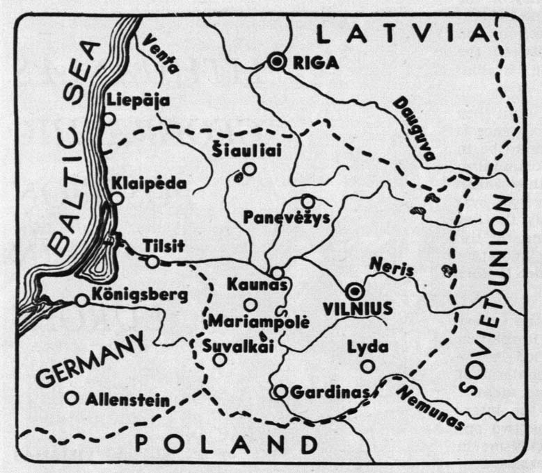 |
| A Map of Lithuania. The Boundaries were established by the Lithuania-Soviet Treaty of July 12, 1920. |
TERRITORY
The territory of the state of Lithuania did not comprise all the Lithuanian lands. Lithuania is not to be understood as only the territory of the state but as the territory of ethnographic Lithuania, where the Lithuanian language is still spoken and where even Lithuanian names of localities and other national characteristics still prevail, where there is a clear ethnological and ethnographical Lithuanian type.
Lithuania is the land where Lithuanians have been living for ages, and where they have toiled to change the natural landscape into one specifically Lithuanian in its culture and civilization. The minimum area of ethnographical Lithuania is considered to be not less than 100,000 sq. km.
The state of Lithuania covered an area of 55,688 sq. km (21,484 sq. miles. 1 square mile equals 2.59 sq. km; or 1 sq. km equals 0.386 square miles! after World War I. 2,848 sq. km of this territory comprised the Klaipeda (Memel) region, which is a part of Lithuania Minor. A large section of ethnographical Lithaunia in the East with its largest city and ancient Lithuania's capital Vilnius (Vilnai was occupied by the Poles; this was approximately 32,000 sq. km.
In 1939 a small segment of this territory which
included Vilnius was returned by Soviet Russia to Lithuania, and later
a little more; therefore, the Lithuanian Soviet Republic territory
covers an area of about 65,197 sq. km.
Lithuania's present geographical surface is accounted for by glaciers which moved south from the Scandinavian mountains during the Ice Age covering Lithuania with moraines. The moraines vary in depth. Some are just a few metres deep, while the depths of others range from 200 to 300 metres (700 to 1,000 feet). After the glacial period Lithuania's surface was given its final formation by flowing waters — streams and rivers which performed the gigantic task of drainage and which make up the present Lithuanian hydrographical network. Lithuania's largest river is the Nemunas which flows through Kurishes Haff into the Baltic Sea. Other large Lithuanian rivers are its tributaries: Merkys, Neris, Nevėžis, Dubysa, and Šešupė. The river Nemunas is 937 km in length; its basin covers an area of 98,000 sq. km.
Lithuania's high points, hills are made from moraines whose maximum height reaches 320 metres above sea level. The high points are found in Upper Lithuania (Aukštaitija), Sūduva, Dzūkija, and Central Samogitia (Žemaitija). The most sharply defined surface was caused by the last Glacial Period which did not cover all of Lithuania's territory. The Ašmenos moraine ridge,, the plateaus of Lyda and Naugardukas were not touched by the last Glacial Period. A clear difference can be seen between the nature of these highlands and the highlands mentioned above. In the last mentioned plateaus there are practically no lakes. They have been drained or have been formed into peat bogs.
The morainic hills are scattered in the East. South, and West of Lithuania and between the hills are broad depressions, formerly occupied by the lobe of a glacier or cut by the waters of the melting ice. The most remarkable regions are covered by terminal moraines and lakes.
From all of Lithuania's surface, the cultivated land presents 52%, natural meadows and pasture land 21%, forest 19%, and 7% lakes and other waters.
CLIMATE AND FLORA
Lithuania belongs to the Central European climate belt and the transitory zone between Europe's oceanic and continental climate. The oceanic and continental climates strike a balance in that country. The Gulf Stream influences Lithuania's climate to the extent that the average yearly rise in temperature fluctuates between 6°—7° C. The warmest month is July, when the temperature in Vilnius is 19° C, and on the sea coast 16° C. The coldest month is January when it is 6.4° C below zero (in Kaunas); while February is the coldest month on the sea coast. The yearly average temperature can be found in the months of April and October.
The average rainfall in Lithuania is 580 mm per year. August is the month with the highest rainfall, an average of 93 mm. The rivers and lakes are usually covered with ice for 100 to 120 days and thaw out in March or April.
From the botanical point of view Lithuania belongs to the "variety" forest zone. In ancient times the forest consisted mainly of leaf-bearing tree lands which were cleared and turned into arable land. At the present the evergreens are predominant, that is the pine and fir trees. Pine trees are found mostly in sandy soil which is not suitable for farming, and the fir trees in moist soil which is also unsuitable for cultivation. Oak, lime, pine, and fir are typical trees of Lithuanian forests.
The following cultivated plants grow best: oats, rye, sugar beets, and flax. Of these flax grows particularly well, which makes Lithuania one of the leading countries in Europe for growing and exporting flax.
INHABITANTS
There were about 2,550,000 inhabitants in Lithuania in 1938. Under an imposed agreement with the USSR on October 10, 1939, Vilnius and the territory surrounding it were returned to Lithuania, an area of 6,880 sq. km and approximately 650,000 inhabitants. For the entire nation there were 48.9 inhabitants per sq. km.
According to the statistics for 1938, not including the region of Vilnius, the racial structure of Lithuania was as follows: Lithuanians 81%, Jews 7%, Germans 4%, Poles 3%, Russians 2.3%, and others 2.7%. According to religion: Roman Catholics 80.3%, Protestants 9.5%, Jews 7.2%.
With the return of the Vilnius territory, the extermination of the Jews by the Nazis, refugees going to the West, the mass deportation of Lithuanians to Siberia and other parts of Soviet Russia, and the new Russian colonization, the picture of the inhabitants of Lithuania has changed a great deal, and there is lack of sufficient information concerning these adjustments.
In 1940, 77.2% of the population lived on the land and 22.8% in the cities. According to occupation, the inhabitants of Lithuania were divided as follows: agriculture 77%, industry 6.6%, commerce 2.5%, transportation 1%.
Until the nineteenth century most of the people lived in various types of villages. When serfdom was abolished in 1861, the villages began to break up into individual farms. Entire villages were practically eliminated by the land reform of independent Lithuania. At the same time there followed the breaking up of The landed estates which formerly were owned, for the most part, by a foreign aristocracy which used old-fashioned methods in farming. The peasants became landlords and they accomplished excellent results.
THE LARGER CITIES
Vilnius (Vilna) with 208,000 inhabitants. From ancient times the most important Lithuanian city and capital. Abundantly supplied with beautiful churches, some of great architectural beauty, and other ancient buildings. From the fourteenth to the eighteenth centuries it was the most important city in Eastern Europe and was equal in importance to Moscow, Cracow, Novgorod, Kiev. During the Russian and Polish occupational periods it was only a provincial city.
Kaunas — 158,000 inhabitants. Also an ancient city at the junction of the rivers Nemunas and Neris. Until Vilnius was returned to Lithuania, Kaunas was the most important city of Lithuania. While in independent Lithuania it expanded to several times its size.
Klaipeda (Memel) — 50,000 inhabitants. Lithuania's only port. Klaipeda, under the Lithuanian government, developed and expanded to a great degree. The port of Klaipeda's tonnage turnover, in comparison with figures back to World War I, has expanded three times, and increased in value. For during the German period, Klaipeda was mostly a timber exporting center, while during Lithuanian period its import and export were of a far greater variety of merchandise, raw products, and food. Through the port of Klaipeda about 90% of Lithuanian exports and imports were handled.
Other larger cities in Lithuania were: Šiauliai — 32,000 inhabitants, Panevėžys — 27,000, Mariam-polė — 16,000, Ukmerge — 13,000, Alytus — 10,000, Tauragė — 11,000.
Well-known summer resorts are Palanga, a beautiful seaside resort, Nida and Juodkrantė, two lovely watering-places between the Lagoon and the Baltic Sea, and Birštonas, a famous health-resort having mineral water springs with healing properties.
Lithuania at present is a vast prison where men,
in order to survive, must work for a slave state that recognizes no
right to life, liberty, or the pursuit of happiness. Lithuanians are
waiting for the day when Lithuania will again emerge from the tomb and
rise up for the fulfillment of its mission.