|
LITUANUS
LITHUANIAN
QUARTERLY JOURNAL OF ARTS AND SCIENCES
Volume 10, No.2 - Summer 1964
Editor of this issue: Thomas Remeikis
ISSN 0024-5089
Copyright © 1964 LITUANUS Foundation, Inc.
|

|
DR. POVILAS REKLAITIS
POVILAS REKLAITIS, Lithuanian art
historian, a
frequent contributor to scholarly journals, holds a Ph. D. from
University of Tuebingen (1949). His latest work is: Einfuermig in die
Kunat-gesckichtsforschung des Grossfuerstentuma Litauen,
Marbug-Lahn,
Herder Institute, 1962.
THE PROBLEM OF THE EASTERN BORDERS
OF GOTHIC ARCHITECTURE
Historical
Background
In the middle ages, Europe was not
homogeneous; it was divided into the
East and the West. The loss of a unifying factor is presupposed in
discussing this division: during the final days of antiquity, the
factors fostering the unity of Europe were the Roman Empire and her
conceptual counterpart, the Christian Church which had enveloped all of
the Roman Empire by the third century A.D. The divisive process began
early, for the inner structure of the Roman Empire was heterogeneous
from the standpoint of nationality: it ruled a large number of nations
of diverse origins. The Greek and Roman nations contributed most, both
spiritually and materially, to this culture: the Latin and the Greek
languages existed side-by-side in the Roman Empire. In this national
and linguistic division lies the first cause of the split within Europe
The cleavage of the Roman Empire was
also fostered by the
administrative - national politics of the Roman Emperors. The first
steps toward the division were taken by Emperor Diocletian as early as
the year 294 A.D. Constantine the Great having restored the unity of
the Empire, in 330 A.D. established his residence in Byzantium, the
Greek city near the Bosphorus, which then became Constantinople. Thus
Constantine laid the foundation of the Eastern and Byzantine Empires.
Rome, no longer the capital, lost power, prestige, and population. The
testament of Theodosius the Great
finalized the partition of the Empire into the Western - Roman and the
Eastern - Byzantine Empires. The weak West soon fell into the hands of
the Teutons. The Western Empire ceased to exist in 476, while the
Byzantine Empire survived until 1453. The Western Empire was restored
on a new foundation through the crowning of the Erankish king,
Charlemagne, as Emperor by Pope Leo III in the year 800. The traditions
of this essentially symbolic empire, subordinate to the Pope at Rome
and consecrated by the Church — "Sancrum Imperium"
— were
maintained by the German Emperors in the West during the Middle Ages.
Of most consequence to the spiritual
life and culture of that period
was the division of the Church into Eastern and Western factions
— into the Church of Rome and that of Constantinople,
—
which occurred during the early Middle Ages. Administrative
difficulties again were the cause of this rift, especially those
evident in the ninth century, in the lawsuit of Patriarch Photius
during the ratification of the Patriarchy of Constantinople and
culminating in the theological quarrel that resulted in complete schism
in 1054. Several liturgical differences contributed to this schism,
including the worship of icons and the difference in liturgical
languages: Greek in the East, and Latin in the West. In the evolution
of history, the Eastern, as well as the Western Church proved to be
more enduring than the extension of the unity of the Roman Empire in
the political sphere. In the West, the primary unifying factor of
European civilization during the entire Middle Ages was the Roman
Catholic Church with its Popes, who had managed to convert to their
ideals people of different origins — the Teutons and the Neo
-
latin peoples.
This break between the East and the
West was of great significance to
the nations of northen Europe which were inevitably drawn into
differing cultural orbits, either by the West or by the centers of the
Eastern Empire. While the northern Teutonic, western Slavic and the
Hugarian nations fell under the jurisdiction of the Roman Catholic
Church and were bound by political ties to the German emperors, the
Rumanian, part of the southern and eastern Slavic nations followed the
Eastern Church which had been formed by the Greeks and surrendered to
the influence of the Byzantine civilization. The marginal part of the
eastern Slavs, which colonized the nations of Finnish origin in the
northeastern territories, became the
new Russian nation during its expansion and turned against the West
with a threatening force. The antagonism between the East and the West
was not merely limited to the religious and political spheres, but
determined a series of deep-rooted differences within the entire
spiritual and material - technical culture. These differences were most
apparent in art, particularly in architecture.
By the thirteenth century, both
worlds had assumed their positions on
the line which stretched from Finland down to the Adriatic Sea. The
only European nation which had not made its choice by the beginning of
that century was Lithuania. In the thirteenth century and particularly
during the reign of King Mindaugas (d. 1263), Lithuania's ties with the
West became increasingly stronger, despite the fact that the political
orientation of the Lithuanian rulers remained opposed to Western Europe
for the next hundred years or more.1
By the thirteenth century, two
Latin - Catholic dioceses had been established in Lithuania and
appropriate Western military and civil construction methods had been
initiated. As Lithuania turned to the West, the first consolidation of
the great cultural line of demarcation occurred.
Despite the colossal differences
between the two cultures, this
boundary line was still not rigidly defined, but had a peculiar and
complex history during the fourteenth and the fifteenth centuries. It
was influenced by political events, economic changes, religious and
artistic currents from either side. Lithuania's geographical position
was continuously changing — the culture itself, which existed
near this line, was always assuming new-patterns in the religious,
artistic, and technical areas.
The history of architecture indicates
that in the fourteenth and
fifteenth centuries, the Gothic architectural style took form in the
West and soon spread over the entire Western World. Of all the Western
architectural styles, Gothic architecture in its structural system and
architectural decorations and ornaments stands furthest removed from
the Eastern Byzantine architectural style. Thus, the spread of Gothic
architecture most vividly symbolizes the unity of Latin - Western
Europe. Any attempt to explain the development of Western culture in
the realm of architecture must first be preceded by the resolution of
the problem of Gothic architecture's eastern borders.
Treatment
of the Problem in Art History
Interest in the eastern borders of
Gothic architecture developed rather
late and even today this question is not fully answered in all of its
ramifications and details. The reason behind this prolonged lack of
interest in this question lies in the idealistic character of the
history of art (to which the history of architecture naturally
belongs). Academic art history, having developed from art theory which
seeks ideal models for artistic creations and from aesthetics which
seeks to experience perfect beauty, concentrated its attention upon the
most perfect products of artistic creativity — the
masterpieces.
Having established the search for the highest artistic value as its
object and goal, academic art history was not interested in the
totality of the arts without having first made its selections according
to qualitative evaluative criteria. For this reason, art history, not
having complete statistical data, was not able to explain more
precisely the various aspects of the diffusion of art objects. Even
today, art history has still not become as completely a part of history
of culture as it must, if it is to remain a science.
For a long time, Western art history
almost ignored the architecture of
the Western World's eastern territories, either completely
circumventing it or noting it only in passing, as if it were something
of little significance. Therefore, Western art history has long been
unable to clarify the phenomena of its own Western culture such as
Gothic arcitecture and the issue of boundaries and territorial limits
which were delineated inaccuratelly in textbooks and atlases. In the
best French and German art history textbooks printed in several
editions before the first World War (those of Michel, Springer,
Weor-mann, Luebcke, and others) one finds only a few lines or no
mention at all of the monuments of the Baltic countries, Poland, or
Hungary. (Furthermore, the latest books on the synthesis of the history
of Western architecture such as that of Pevsner (1957) or of F.
Baumgart (1960) completely ignore the architecture of these lands which
belong to the Western tradition.) It is true that no specific studies
of the artistic monuments in the eastern countries have been made for a
long time. It was impossible to prepare such studies because the
countries on the eastern border of the Western World were under foreign
domination. Secondly, the explanation of the geographic boundaries of
the expansion of any artistic form is not the task of art history as
much as of art geography.
But art geography is a relatively new science. A serious reason
prevented its development earlier — the lack of a systematic
inventory of art monuments, which was begun in Western Europe in Alsace
around 1870 and which has not yet been fully completed in all
countries.2 Such inventories
were and are lacking for the countries at
the eastern border of Western culture.
Polish
Studies of Eastern Borders of Gothic Architecture
The situation began to improve after
the first World War, when several
nations at the eastern border of the Western World regained their
independence and began to carefully investigate their cultural-artistic
heritage through individual studies and through systematic inventories
of their entire artistic heritage. The Poles initiated the overall
examination of the problem of the eastern border of Gothic
architecture, for during the period of 1920-1939, an important part of
this border existed within Poland.
In 1935, the bulletin of the
Technical University of Warsaw published
an interesting map (1:10,000,000) called "The Expansion of Gothic
Architecture in Eastern Europe (from the Baltic Sea to the
Carpathians.)" The map was prepared according to the findings of a
group of art historians (J. Dutkiewicz, St. Herbst, St. Lorentz, Ks.
Piwocki, O Sosnowski, M. Walicki). This map represents the first
attempt to employ cartography in special investigations and studies
designed to explain problems of a wider scope.3
The publishers had
planned to prepare additional maps which were to comprise a special
atlas of the history of Polish art and culture. A total of 40 Gothic
architecture border monuments were listed on the published map. (See
Illustration No. 1 for the geographic location of monuments listed
below).
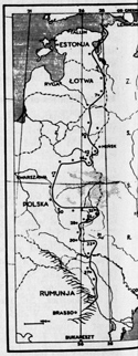 |
| 1.
Eastern border
of
Gothic
architecture, from the
Bay of Finland to the Carpathian Mountains. This map was published by
Polish scholars in 1935. |
Estonia:
1. Narva. A castle (See Illustration No. 3).
2. Vasknarva (Neuschloss in German, Sereniec in Russian) A castle.
3. Tartu. A castle.
Latvia:
4. Aluksne (Marienburg in German). A castle.
5. Vilaka (Marienhausen in German). A castle.
6. Ludza (Ludsen in German, Lucyn in Polish). A castle.
7. Volkenberga (Walkenburg in German). A castle.
8. Daugavpils. A castle.
Lithuania
- Belorussia:
9. Kamojys (Komaje). A church.
10. Kriavas (Krewo). A castle. (See Illustration 4a, 4b, 4c).
11. Kaidanava (Kojdanow). Protective wall of a church.
12. Myrius (Mir). A castle. (See Illustration 5a, 5b, 5c).
13. Kleckas (Kleck). A castle. (See Illustration 6).
14. Iskolde (Iszkoldz). A church.
14. Sinkoviciai (Synkowicze). Protective Orthodox church. (See
Illustrations 7a, 7b).
16. Ilniczno. A church.
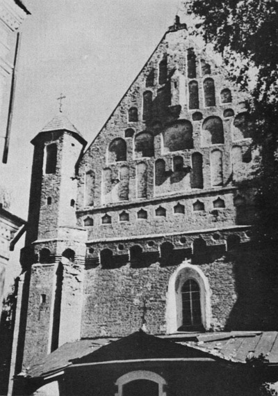
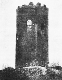
17. Lietuvos Kamenecas (Kamieniec Li-tewski). Tower. (See Illustrations
8a, 8b).
18. Kodenas (Koden). Orthodox church.
Poland:
19. Bielawin. A tower.
Ukraine:
20. Zimno. Orthodox church.
21. Luck. A castle.
22. Klewan. A castle.
23. Ilubkov. A castle.
24. Korzec. A castle.
25. Ostroh. A castle and an Orthodox church.
26. Miedzyrzecz Ostrogski. Orthodox church.
27. Nowomalin. A. castle.
29. Zbaraz (?). A castle.
30. Trembovla. A castle.
31. Mežibiz (P. Międzyboz) (?). A castle.
32. Leticev. A church.
33. Sutkivce. A protective Orthodox church.
34. Kamenec-Podolsk. A castle.
Rumania:
35. Chocim. A castle.
36. Dorohoj. Orthodox church.
37. Botosani. Orthodox church.
38. Havlan. Orthodox church.
39. Roman. Orthodox church.
40. Bacau. Orthodox church.
0. Sosnovski has already attempted to
draw
several conclusions from this first cartographical work on the eastern
borders of Gothic architecture:
1.
The eastern boundary line is oriented directly
North-South. Only the areas such as the lowlands of Polesic and the
swamps at the upper part of rivers
Horyne and Bug are circumvented by this line and remain to the East of
it, because these area were less accessible and thus less influenced by
the Western civilization.
2. This boundary line, stretching from the Baltic Sea to the
river Dienster, follows almost exactly the political border of the
Soviet Republic as it existed in 1935.
3. Thus, Latin civilization which had been documented during the Middle
Ages by Gothic architecture, appeared in the waning
days of this epoch in the confrontation - zone of two diferent and
opposing cultures — those of Europe and
of Eurasia. On one side, this zone was represented by Estonia,
Latvia, Poland, and Rumania; on the other, by Russia.4
We should be surprised by the fact
that Sosnovski said not a word about
the significance of the Lithuanian group of Gothic monuments
— a
significance which was clearly apparent from this map. Thus, his
assertion that, through some natural determinism, the architecture of
the Latin West had to take a detour around the swamp region cannot
convince us. In the seventeenth century when the historical situation
had changed, why did the Jesuits build an extensive college campus,
monastery, and church in Pinsk, the very center of the cited swamp
region? Of much greater import and significance is the fact that the
Lithuanian nation, having maintained the ancient pagan religion within
its ethnic borders until the 13th -14th centuries and not having
surrendered to the mission of the Eastern Church, preserved the
necessary vacuum for this space, which the Roman Catholic religion and
the Western Gothic could easily and widely occupy in the 14th-15th
centuries, beginning with the capital, Vilnius. In the 15th-16th
centuries, the Gothic style spread into the East and the South. The
cultural activity of Lithuania and Vilnius was so dynamic, that in
several places the characteristic qualities of the Gothic style
conquered the religion and language barriers and had influenced the
architecture of some border areas of Belorussia. That the contrary did
not occur in this border area between the East and the West is the
contribution of the Lithuanian nation: a contribution ignored by the
Polish
scholar, even though it is clearly evident in the flow of the Gothic
architecture's boundary line.
German and Ukrainian
Studies
An illustrated map, "The Borders of
Gothic Architecture" was published
in 1939 in the German publication Euro-pa und der Osten.5 (See
Illustration No. 2). It was clearly drawn using the cited map published
in the bulletin of the Technical University of Warsaw, for the sequence
of the border monuments as well as the course of the very boundary line
to the North, into Finland and to the South, into Sep-tynpilis,
Hungary, and Croatia was not shown ; this also indicates that the
authors of the German publication based their work on the map prepared
by the Polish. However, the German map offers some additional
information. Individual monuments are marked by special signs such as:
1) Locality with a Gothic
castle or palace (supplementary
information is given for Bauske and Vilnius (Wilna) with a
drawing of the facade of the Church of St. Anne.)
2) Locality with a Gothic church or monastery belonging to the Roman
Catholics (supplementary information is given for Tartu-Dorpat, Zips,
and Warsaw.)
3) Locality with a Gothic church or monastery belonging
to the Greek Orthodox Church (Pskov is given additional identification.)
4) Locality with a Gothic fortification or municipal buildings
(supplementary data is presented for Lzublin, Kazimierz near the river
Vysla, Zips.)
5) Locality with numerous Gothic artistic monuments
(Tallin, Riga, Kaunas, Sandomir, Lvov are given supplementary
identification.)
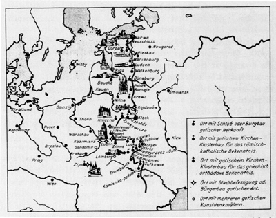
2. Eastern border of Gothic
architecture. This map was published by German scholars in 1939.
Even though the supplementary
information is usually provided in
visual, illustrative form, the statement about the Gothic architecture
in Pskov merits further notice. The towers of Lietuvos Kamenecas
(Kamenec Litewski) and Bielawin are identified as fortifications. This
is unacceptable, because these towers are most likely the remains of
old castles and not of a city.
In 1942, Dmytro Antonowytsch, an
Ukrainian art historian, criticized
this German map of the Gothic eastern border, but did not note the
Polish origin of this map.6 In
his opinion, the above-mentioned German map needs
correction
with reference to the Ukraine, where Gothic monuments are found much
further to the East. The German and Polish literature persistently
maintains the false idea that Gothic monuments are found only in the
western part of the Ukraine, while Gothic architectural monuments are
found throughout all of the Ukraine, such as the once famous
"Lithuanian castle" in Kiev, destroyed with all of its contrivances in
the seventeenth century. The Dominican Church of St. Michael in Kiev,
which was finished in 1610, was also Gothic. It had a three-bay hall
with a high roof and high windows with pointed arches. This church was
destroyed only in this century by the Communists. "Far across the
Dniepr, in the Lubny residence of the ducal Visniavecki family, all of
the stone architecture had a pure Gothic form at the end of the
sixteenth century and during the first half of the seventeenth." 7
According to Antonowytsch, all of the stone buildings in the Ukraine,
built between the fourteenth century and the first third of the
seventeenth, were Gothic. Because of the many Tartar assaults, however,
only a few of these buildings have remained. Beyond the delineated
Gothic eastern border, remains of Gothic castles and fortresses are
found in several other places such as Svjahel, Žitomir, and Bar.8 If
the facts presented by Antonowytsch are accurate, they completely
negate the conclusions drawn by Sosnowski.
A
Critical Conclusion
The first attempts to map the eastern
border of the Gothic style and
the critique of these attempts demonstrate the complexity of this
problem: so far, the basic premises have not been fully explained.
Specific investigations and correctly dated chronologies of many
monuments are lacking. A good part of the monuments ascribed to the
Gothic style are of a considerably later period and belong to the
second half of the sixteenth century or even to the seventeenth. Can
one agree with Anto-nowytsch's opinion that until the seventeenth
century, the provincial masons of the Ukraine were trained only in the
Gothic tradition and thus all of their buildings in the sixteenth and
seventeenth centuries can automatically be classified as Gothic? To
support his conclusions, Antonowytsch does not present any precise
criteria for the classification of Gothic masonry techniques. A
detailed analysis of the form of every monument is unavoidably
necessary.
Without it, one
cannot answer the question whether the Renaissance movement of the new
epoch, which changed the construction of castles and churches, had
reached the Ukraine and Lithuania in the sixteenth century. What is the
true origin of the Gothic form of the monuments which remain in our
land?
The structural concept should be the
basic principle in establishing
the eastern border of Gothic architecture. A different problem is
presented by the geographical distribution of individual Gothic
structural elements and ornamental motifs. The ornamental elements
(friezes, niches, shapes of arches, portals, bas-reliefs) of the
Western Romanesque style had already penetrated far into Russia during
the twelfth century.9 Later,
the Gothic style strongly influenced
Novgorod, which contained a Hanseatic colony and had broad commercial
traffic with the West. Archbishop Euphimius, a supporter of the
independence of the republic of Novgorod and an enemy of Moscow's
imperialism, built a stone palace in 1442; its great hall, with
Western-style, pure Gothic ogive, diagonal groin rib-vaults, spouting
from a pilaster in the center of the hall still stands.10 Similarly
vaulted halls existed in the donjon of the Kriavas (Krewo) castle in
Lithuania and in the Gothic buildings near the Convent of St. Catherine
in Vilnius. The Archbishop's hall in Novgorod, which had been used for
the official meetings of the nobility, was decorated with frescoes,
just as the earlier ceremonial hall of the lake Galve castle in Trakai
near Vilnius, Lithuania.
These examples show that the
resolution of the problem of the expansion
of Gothic forms demands minute re-examination of monuments on both
sides of the hypothetical eastern border of Gothic architecture.
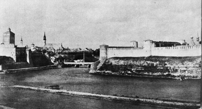
3. Narva. On the left a Gothic castle
(founded in
1276, finished in the fourteenth-fifteenth centuries).
On the right-
Russian Ivangorod castle (founded in 1496, finished in the sixteenth
century).
Photo from the archives of J. G. Herder-Institut,
Marburg,
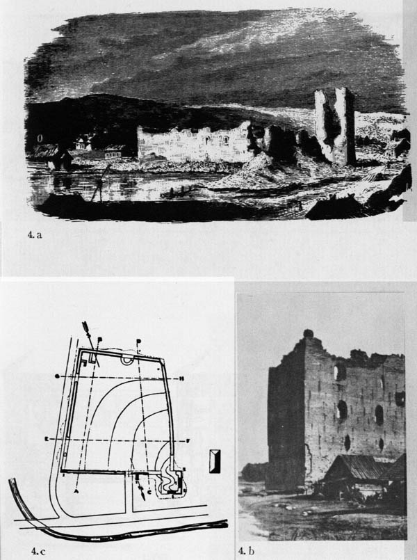
4. The castle of Krewo (fourteenth
century). The
defensive walls axe of irregular trapezoid construction,
a) A view of
castle ruins, from a nineteenth century engraving,
b) Photo of the
donjon, ca. 1910.
c) The plan, according to St. Lorenz, 1930.
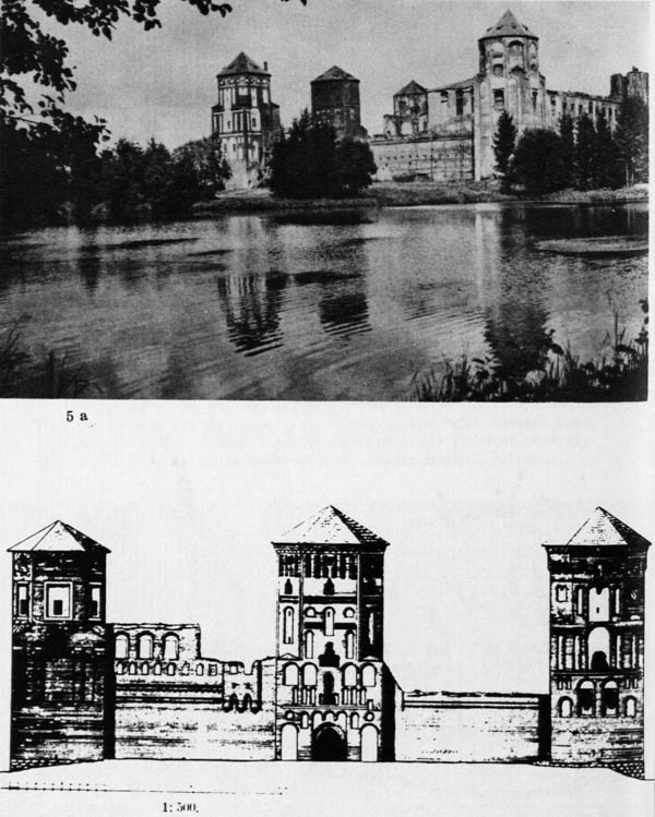
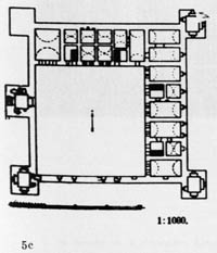
5. The castle of Mir (beginning of
sixteenth
century),
a) A view from the lake-side, ca. 1910.
b) Western facade,
1:500, according to B. Schmid.
c) The plan, 1:1000, according to B.
Schmid, 1942.
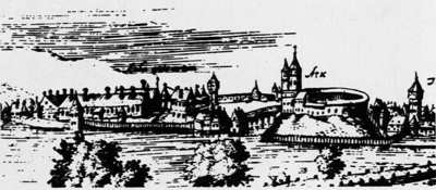
6. The castle of Kleck, from an
engraving by T. Makovski, ca. 1600.
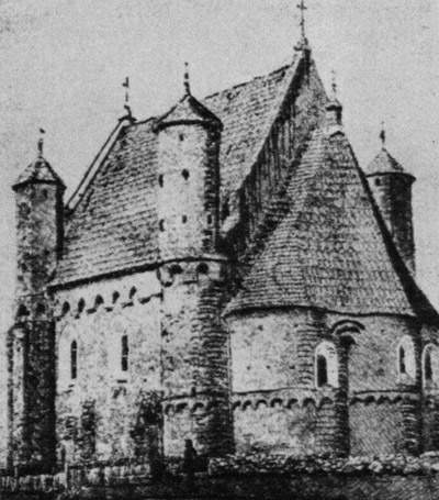
7. The defensive church of Synkowicze
(beginning of sixteenth century),
a) A view from the side of the
prisbyter.
b) Western facade.
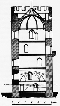
8. A tower in Kamieniec Litewski
(second half of thirteenth century).
The brick donjon of early Gothic was part of a complex of an older
wooden castle,
a) A view before the restoration,
b) A cross-section,
according to P. A. Rappoport, 1952.
NOTES
1 J. Stakauskas, Lietuva
ir Vakarų Europa XIII-me amžiuje - (La
Lithuanie et L'Occident au XIIIe siecle), Kaunas, 1934, p. 261.
2 D. Frey, "Geschichte und Probleme der Kultur-
und Kunst-geographie", Archeologia
Geographica, Hamburg, 1955, Vol. IV, p. 96.
3 "Zasiąg budownictwa gotyckiego na wschodzie Europy (od Baltyku do
Karpat)" (La limite Est de l'expansion
territo-riale de l'architecture gothique en Europe (ligne: Mer
Maltique-Carpathes)), Biuletyn
Historji Sztuki i Kultury, Warszawa, 1935, Vol. III,
No. 3, pp. 166-167.
4 0. Sosnowski, "Prace kartograficzne" (Les travaux
carthographques), Biuletyn
Historji Sztuki i Kultury, Vols. XV-XVI, pp. 165,
168.
5 H Hagenmayer und G. Leidbrandt, "Die Ostgrenze der gotischen
Baukunst", Europa und
der Osten, Muenchen, 1939, p. 142 (2nd ed.
1942).
6 D. Antonowytsch, Deutsche
Einfluesse auf die ukrainische Kunst,
Leipzig, 1942.
7 Ibid., p. 24.
8 Ibid., p. 25.
9 F. W. Halle, Russische
Romanik: Die Bauplastik von Wladimir-Sausdal, Berlin,
1929.
10 W. N. Lasarew, Die
Kunst Nowgorods, "Geschichte der
russischen Kunst", vol. II, Dresden, 1958, p. 52.